Visiting a Conservation Area? Check out these Important Reminders.
Please note: the Laurier Woods Conservation Area maps and brochure is currently under revision to reflect changes in the trails and completion of new boardwalks (including Michael's Boardwalk which now connects the purple trail).
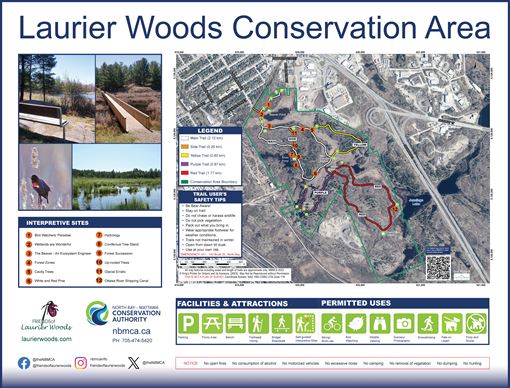
Located in the heart of North Bay, this 250 acres encompasses a provincially significant wetland, rocky outcrops, upland forest and is a sanctuary to a broad range of wetland and woodland creatures, including migrating birds. Interpretive trail sites mark the 6.5 km of trails. Laurier Woods Conservation Area is owned in partnership with the Friends of Laurier Woods. This area is outstanding for birdwatching with 33 species of birds nesting in the Conservation Area.
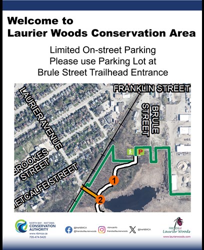
Parking: Please note that if you are driving to Laurier Woods Conservation Area, there is plenty of parking at the Brule St. entrance/trailhead. The entrance off Laurier St only has very limited on-street parking spots available which are shared with the residents on the street. Please use the Brule St. entrance and parking lot.
Trails identified on map.
Laurier Woods Conservation Area Trail Map
Laurier Woods Conservation Area Trail Brochure
Donations to Preserve Laurier Woods Conservation Area
Financial donations are also accepted on an on-going basis to support the upkeep, maintenance and ongoing improvements to Laurier Woods Conservation Area. A charitable receipt will be issued for $20.00 or more. Consider an annual commitment to help sustain the conservation area.
Directions: From the HWY 11/17 junction near Seymour Street, head northwest on HWY 11/17 and take a left at Seymour Street. Turn right at Franklin Street, and then left onto Brule Street where you will find a parking area and new trail signage.
Visiting Laurier Woods Conservation Area! Lots of parking available in the parking lot at the Brule Street Entrance. This is the head of the trails, great spot to start your walk along the trails!


