Watershed Conditions Statement - Water Safety
Message Number: 2026-22
Issued: July 28, 2026 at 12:00 PM EDT
From: NBMCA Duty Officer, Githan Kattera
Watershed Conditions Statement – Water Safety indicates that high flows, unsafe banks, melting ice or other factors could be dangerous for users such as anglers, boaters, swimmers, children or pets. Flooding is not expected.
If you have a flood emergency, please contact your municipality. If you live in an unincorporated township, please contact the Ministry of Natural Resources (MNR) – North Bay District.
The North Bay-Mattawa Conservation Authority (NBMCA) is responsible for monitoring and providing information related to river and lake-based flooding within its watershed.
Watershed Conditions Statement – Water Safety is currently in effect for the North Bay-Mattawa watershed.
This is an update to Message No. 2026-21, issued on July 27, 2026.
The previously issued Flood Watch has been downgraded to a Watershed Conditions Statement – Water Safety.
Current Conditions:
Thunderstorms on July 27, 2026, produced 40–60 mm of rainfall across portions of the North Bay-Mattawa watershed. In response to the recent rainfall, water levels and flows increased significantly across the watershed.
Water levels and flows are now generally stabilizing; however, conditions remain variable across the watershed, and some areas continue to experience elevated or increasing water levels.
Watershed conditions remain sensitive due to the recent significant rainfall. Many areas across the watershed remain wet and vulnerable, and any additional rainfall could result in rapid increases in water levels and flows in rivers, streams, and creeks.
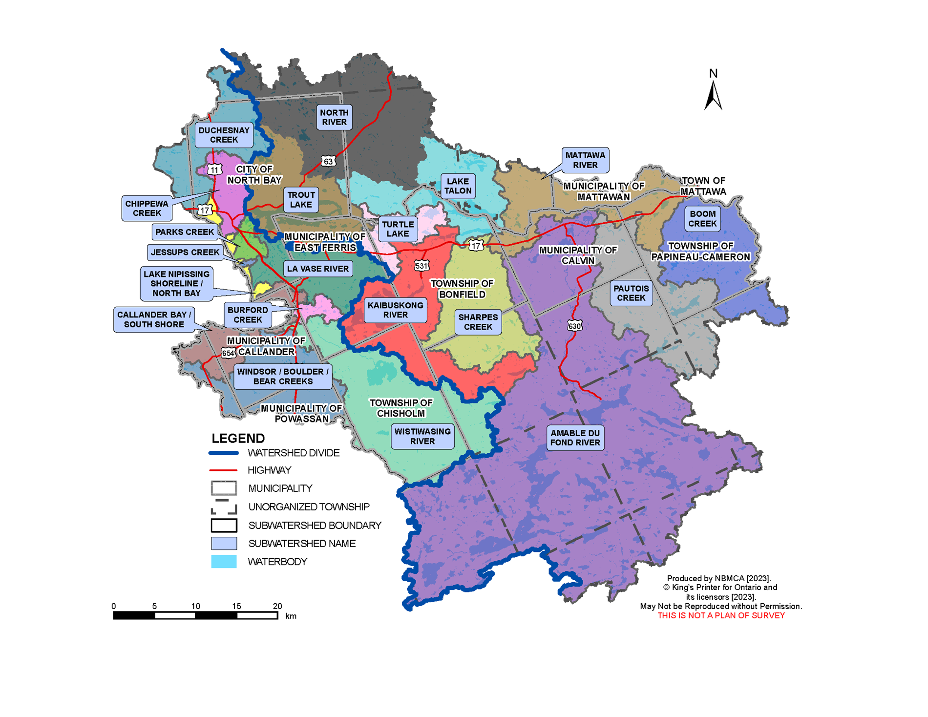
Current water levels can be viewed by searching Station Names “Ottawa River”, “Mattawa River”, “Chippewa Creek”, “La Vase River”, “Wasi River”, and “Lake Nipissing” at https://wateroffice.ec.gc.ca/search/real_time_e.html
Forecasted Conditions:
Very little additional rainfall is forecast, with approximately 5 mm of total rainfall expected over the next five days. The convective forecast indicates the potential for localized rainfall amounts of up to 10 mm.
Although the overall rainfall forecast remains low, localized thunderstorms can develop quickly and produce higher rainfall amounts over small areas. Due to the recent rainfall received across the watershed, additional localized rainfall could result in rapid increases in water levels and flows in rivers, streams, and creeks.
Historic Flood Conditions:
For comparison, in response to intense rainfall of 25 mm in 45 minutes, and a total of 37 mm on June 26, 2023, water levels on Chippewa Creek rose by 120 cm in 90 minutes. Additional rain of 53 mm on June 27 caused water levels to rise again by 108 cm, with most of the increase occurring in less than three hours.
Risk:
A Watershed Conditions Statement – Water Safety is issued for the NBMCA watershed. Widespread flooding similar to the conditions experienced this spring is not anticipated at this time. However, recent significant rainfall has resulted in elevated water levels, and many areas within the watershed remain wet and vulnerable.
Additional localized rainfall, particularly from thunderstorms, could result in rapid changes in water levels and flows, especially in smaller rivers, streams, and creeks
All residents, especially those in low lying areas, are encouraged to monitor the conditions that are developing. Banks adjacent to rivers and creeks are very slippery at this time and pose a serious hazard. The public is encouraged to keep children and pets away from watercourses.
Municipalities are encouraged to monitor water crossings for debris that may affect the movement of water through culverts and bridges. A close watch on local conditions and updated forecasts and warnings from Environment Canada is also recommended.
Staff at the North Bay-Mattawa Conservation Authority will continue to monitor weather and watershed conditions and update this message based on the changing weather and streamflow conditions.
This message will be in effect until (or updated before) Thursday, July 30 at 4:00 PM EDT.
Community Engagement
The general public is advised of these messages through the www.nbmca.ca website with the flood status icon and a link to information about current conditions. NBMCA also circulates these messages to local media and social media, posting on Twitter (@theNBMCA), Instagram (nbmcainfo), and Facebook (NBMCA).
The public is invited to share photos of watershed conditions on social media using #NBMCAFlood.
Lake Nipissing
Flows through the dams are based on daily analysis of the current status of the lake and river and as agreed to by the Sturgeon-Nipissing-French-Wanapitei Water Management Group. Weather forecast is considered, along with the inflows from the upper watersheds and outflows through the dam to the French River.
You can view the current level on Lake Nipissing at North Bay on the graph below and the French River at the Water Survey of Canada (WSC) website. Fluctuations in the levels are a result of the strong winds affecting the movement of surface water. Water level and flow information for the South River and Sturgeon River systems is available from Ontario Power Generation (OPG).
Flood warnings for Ontario can be found on the Ontario Flood Forecasting and Warning website.
Why the fluctuation in water level readings on Lake Nipissing? Lake Nipissing can sometimes act like a bathtub, with water shifting in the lake, depending upon wind direction, speed and atmospheric pressure - known as a wind surge or seiche. At times the wind can have such an impact that it may result in the level being higher or lower at the French River gauge compared to the gauge located on the North Bay shoreline.
Mattawa River
The current Ottawa River water level may be viewed at the Water Survey of Canada (WSC) website (note that there is a delay of several hours, and 100m should be added to the gauge reading for metres above sea level).
The Ottawa River Regulation Committee and Ontario Power Generation which operates the Otto Holden Dam provide information online regarding the management of water levels on the Ottawa River. To view water levels and current conditions on the Ottawa River visit the Ottawa River Regulation Planning Board and Ontario Power Generation.
Watercourses and Monitoring throughout the Watershed
There are other watercourses within the NBMCA jurisdiction which are monitored by NBMCA and other agencies. These gauges are maintained by Water Survey Canada - Environment Canada and can be viewed in real-time online.
- Chippewa Creek at North Bay
- Lake Nipissing at French River
- Lake Nipissing at North Bay
- La Vase River at North Bay
- Ottawa River at Mattawa
- Wasi River near Astorville
In addition to the Water Survey of Canada gauges, there are other staff gauges which are monitored by NBMCA or the Ministry of Natural Resources and Forestry:
- Chippewa Creek
- Lake Nosbonsing Dam
- Mattawa River at Hurdman Dam
- Parks Creek
- Trout Lake
- Turtle Lake
- Talon Lake
Is your property at risk of flooding?
If you think that your property may be at risk of flooding, please contact your municipality.
If you live in an unorganized township, contact Ministry of Natural Resources and Forestry District office at 705-475-5501.
More Information
- The North Bay-Mattawa Conservation Authority delivers its flood forecasting program and updates for municipalities, agencies, our partners, and the public as part of our natural hazard management initiatives. These updates are based on the analysis of data and information collected in concert with the following:
- Environment Canada (Weather)
- Mattawa River below Bouillon Lake
- Ministry of Natural Resources and Forestry
- North Bay-Mattawa Conservation Authority
- Ottawa River Regulating Committee
- Ottawa River Regulation Planning Board
- Public Services and Procurement Canada
- Sturgeon-Nipissing-French-Wanapitei Water Management Group
- Surface Water Monitoring Centre
- Water Survey of Canada
- Weather Network