Watershed Conditions Statement – Flood Outlook
Message Number: 2026-03
Issued: March 13, 2026 at 3:00 PM EDT
From: NBMCA Duty Officer, Githan Kattera
Watershed Conditions Statement – Flood Outlook gives early notice of the potential for flooding based on weather forecasts calling for heavy rain, snow melt, high wind or other conditions that could lead to high runoff, cause ice jams, lakeshore flooding or erosion.
If you have a flood emergency, please contact your municipality. If you live in an unincorporated township, please contact the Ministry of Natural Resources (MNR) – North Bay District.
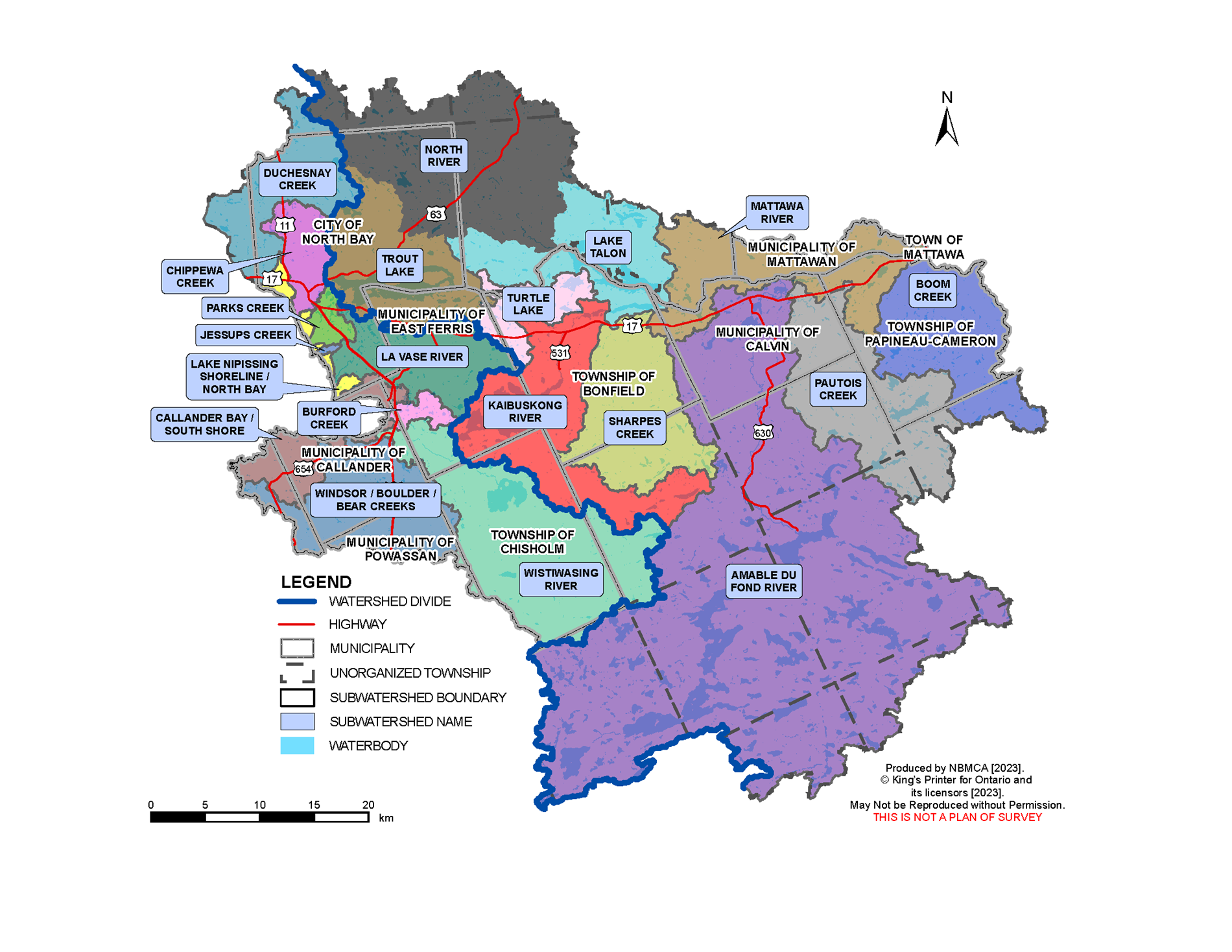
A Watershed Conditions Statement – Flood Outlook is in place for the North Bay-Mattawa watershed.
Current Conditions:
Water levels on area lakes and rivers are generally at or slightly above normal for this time of year. Water levels have increased in response to several days of mild temperatures, rainfall, and snowmelt in the past week. Significant water content remains stored in the snowpack, with an average of 108 mm (as of Mar 9). The remaining snow is very wet and unstable, and many wetlands and low-lying areas across the watershed remain inundated.
Current water levels can be viewed by searching Station Names “Ottawa River”, “Mattawa River”, “Chippewa Creek”, “La Vase River”, “Wasi River”, and “Lake
Nipissing” at https://wateroffice.ec.gc.ca/search/real_time_e.html
Forecasted Conditions:
Up to 25 mm of rainfall is forecast from Sunday night through Monday, with daytime temperatures reaching 8 °C and nighttime temperatures dropping below freezing. These conditions are expected to trigger snowmelt.
The water level of Lake Nipissing continues to be drawn down, though water levels have stabilized in response to last week’s melt. The changes to water levels on Lake Nipissing depend on the amount of water flowing in from rivers, precipitation, snowmelt, and the amount of water flowing out through the control dams to the downstream French River. https://www.canada.ca/en/public-services-procurement/services/infrastructure-buildings/bridges-docks-dams/frenchriver-dam.html
Flows and levels of the Ottawa River at Mattawa are near seasonal values, according to the Ottawa River Regulating Committee. The Ottawa River water levels are managed by dams and reservoirs operated by provincial and federal governments. The Ottawa River Regulation Planning Board posts current data and forecasts on their website https://ottawariver.ca/
Historic Flood Conditions:
For comparison, when flooding occurred in the watershed around April 18, 2019, the snowpack water content was 123 mm (measured April 15, 2019). Daytime temperatures were between 3 and 12 °C, with overnight temperatures above freezing. Actual precipitation measured on April 18, 2019 was 31.8 mm. When combined with snowmelt, the daily average water level on Chippewa Creek, in North Bay, increased by 57.6 cm in that one day.
Risk:
A Watershed Conditions Statement – Flood Outlook has been issued for the North Bay-Mattawa watershed. Water level on some lakes and rivers, including Lake Talon, La Vase River, Mattawa River (upstream of Hurdman Dam), and Wasi River remains high but has been decreasing after last week’s rain. Many low-lying areas and wetlands remain inundated and have limited capacity to store additional water. Forecast rainfall and snowmelt may cause water levels to rise again. Water levels and flows in local streams and rivers, especially those in urban areas could change rapidly especially during and after rainfall. Widespread flooding is not expected; however, flooding and ponding may occur in flood-prone low-lying areas.
All residents, especially those in low lying areas, are encouraged to monitor the conditions that are developing. Banks adjacent to rivers and creeks are very slippery at this time and when combined with cold open water, pose a serious hazard. The public is encouraged to keep children and pets away from watercourses and off waterbodies.
Municipalities are encouraged to monitor water crossings for debris that may affect the movement of water through culverts and bridges. A close watch on local conditions and updated forecasts and warnings from Environment Canada is also recommended.
Staff at the North Bay-Mattawa Conservation Authority will continue to monitor weather and watershed conditions and update this message based on the changing weather and streamflow conditions.
This message will be in effect until (or updated before) Wednesday, March 18 at 4:00 PM EDT.
The general public is advised of these messages through the www.nbmca.ca website with the flood status icon and a link to information about current conditions. NBMCA also circulates these messages to local media and social media, posting on Twitter (@theNBMCA), Instagram (nbmcainfo), and Facebook (NBMCA).
The public is invited to share photos of watershed conditions on social media using #NBMCAFlood.
The public is invited to share photos of watershed conditions on social media using #NBMCAFlood. Media Release
Lake Nipissing
Flows through the dams are based on daily analysis of the current status of the lake and river and as agreed to by the Sturgeon-Nipissing-French-Wanapitei Water Management Group. Weather forecast is considered, along with the inflows from the upper watersheds and outflows through the dam to the French River.
You can view the current level on Lake Nipissing at North Bay on the graph below and the French River at the Water Survey of Canada (WSC) website. Fluctuations in the levels are a result of the strong winds affecting the movement of surface water. Water level and flow information for the South River and Sturgeon River systems is available from Ontario Power Generation (OPG).
Flood warnings for Ontario can be found on the Ontario Flood Forecasting and Warning website.
Why the fluctuation in water level readings on Lake Nipissing? Lake Nipissing can sometimes act like a bathtub, with water shifting in the lake, depending upon wind direction, speed and atmospheric pressure - known as a wind surge or seiche. At times the wind can have such an impact that it may result in the level being higher or lower at the French River gauge compared to the gauge located on the North Bay shoreline.
Mattawa River
The current Ottawa River water level may be viewed at the Water Survey of Canada (WSC) website (note that there is a delay of several hours, and 100m should be added to the gauge reading for metres above sea level).
The Ottawa River Regulation Committee and Ontario Power Generation which operates the Otto Holden Dam provide information online regarding the management of water levels on the Ottawa River. To view water levels and current conditions on the Ottawa River visit the Ottawa River Regulation Planning Board and Ontario Power Generation.
Watercourses and Monitoring throughout the Watershed
There are other watercourses within the NBMCA jurisdiction which are monitored by NBMCA and other agencies. These gauges are maintained by Water Survey Canada - Environment Canada and can be viewed in real-time online.
- Chippewa Creek at North Bay
- Lake Nipissing at French River
- Lake Nipissing at North Bay
- La Vase River at North Bay
- Ottawa River at Mattawa
- Wasi River near Astorville
In addition to the Water Survey of Canada gauges, there are other staff gauges which are monitored by NBMCA or the Ministry of Natural Resources and Forestry:
- Chippewa Creek
- Lake Nosbonsing Dam
- Mattawa River at Hurdman Dam
- Parks Creek
- Trout Lake
- Turtle Lake
- Talon Lake
Is your property at risk of flooding?
If you think that your property may be at risk of flooding, please contact your municipality.
If you live in an unorganized township, contact Ministry of Natural Resources and Forestry District office at 705-475-5501.
More Information
- The North Bay-Mattawa Conservation Authority delivers its flood forecasting program and updates for municipalities, agencies, our partners, and the public as part of our natural hazard management initiatives. These updates are based on the analysis of data and information collected in concert with the following:
- Environment Canada (Weather)
- Mattawa River below Bouillon Lake
- Ministry of Natural Resources and Forestry
- North Bay-Mattawa Conservation Authority
- Ottawa River Regulating Committee
- Ottawa River Regulation Planning Board
- Public Services and Procurement Canada
- Sturgeon-Nipissing-French-Wanapitei Water Management Group
- Surface Water Monitoring Centre
- Water Survey of Canada
- Weather Network